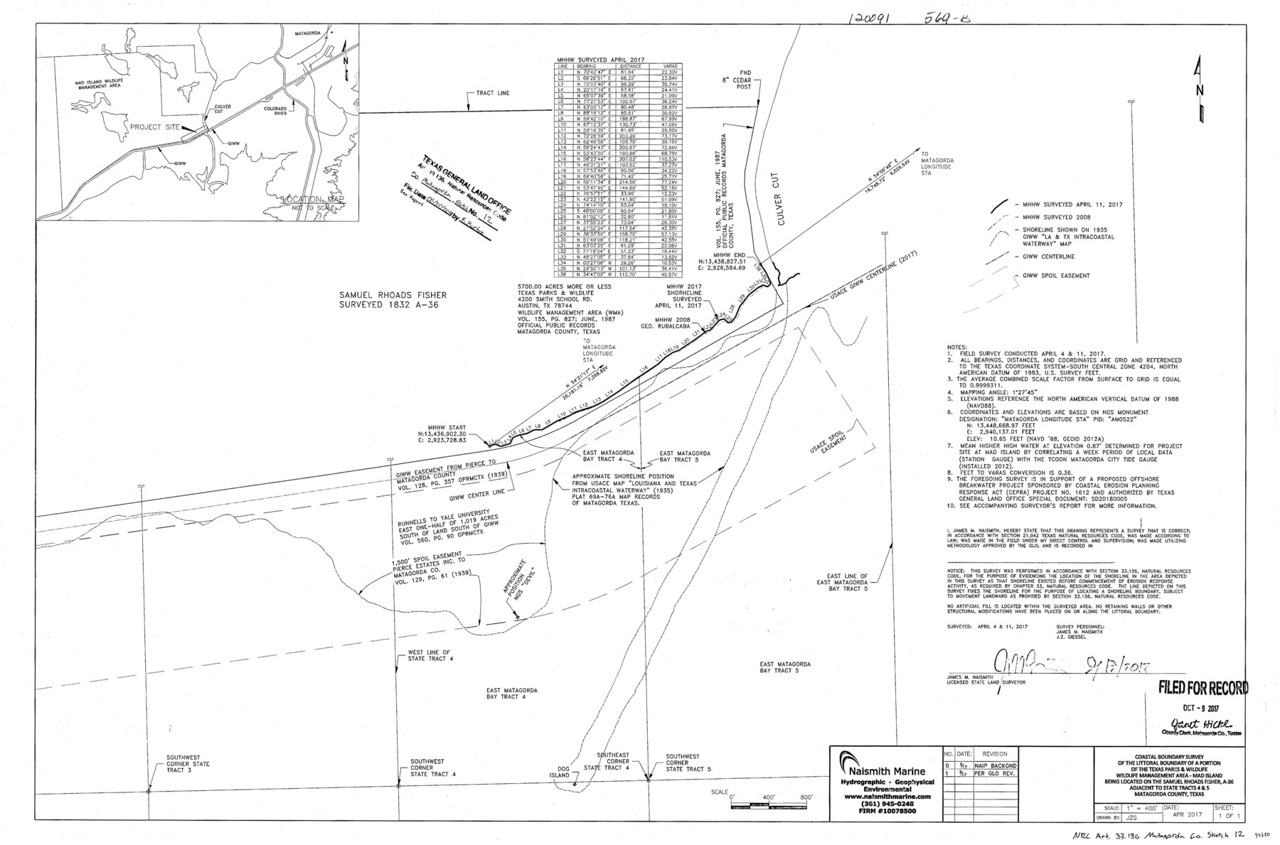
Matagorda County NRC Article 33.136 Sketch 12
Coastal boundary survey of the littoral boundary of a portion of the Texas Parks & Wildlife wildlife management area - Mad Island being located on the Samuel Rhoads Fisher, A-36 adjacent to state tracts 4 & 5
-
Map/Doc
94780
-
Collection
General Map Collection
-
Object Dates
2017/9/19 (Creation Date)
2017/4/11 (Survey Date)
2018/6/20 (File Date)
-
People and Organizations
James M. Naismith (Surveyor/Engineer)
-
Counties
Matagorda
-
Subjects
Surveying CBS
-
Height x Width
22.0 x 34.0 inches
55.9 x 86.4 cm
-
Medium
multi-page, multi-format
-
Scale
1" = 400'
-
Comments
Project: Mad Island WMA Shoreline Protection II Project No.: CEPRA 1612 (GLO); SD20180005 (GLO)
Part of: General Map Collection
Crockett County Rolled Sketch 45

Print $40.00
- Digital $50.00
Crockett County Rolled Sketch 45
Size 54.8 x 16.5 inches
Map/Doc 8710
[Galveston, Harrisburg & San Antonio Railroad from Cuero to Stockdale]
![64202, [Galveston, Harrisburg & San Antonio Railroad from Cuero to Stockdale], General Map Collection](https://historictexasmaps.com/wmedia_w700/maps/64202.tif.jpg)
Print $20.00
- Digital $50.00
[Galveston, Harrisburg & San Antonio Railroad from Cuero to Stockdale]
1907
Size 13.3 x 33.1 inches
Map/Doc 64202
Andrews County Working Sketch 2

Print $20.00
- Digital $50.00
Andrews County Working Sketch 2
1949
Size 23.2 x 23.7 inches
Map/Doc 67048
Sutton County Sketch File JAC

Print $20.00
- Digital $50.00
Sutton County Sketch File JAC
Size 24.5 x 23.4 inches
Map/Doc 12398
Wilbarger County Sketch File 28

Print $20.00
- Digital $50.00
Wilbarger County Sketch File 28
2016
Size 23.9 x 36.2 inches
Map/Doc 95324
Right-of-Way & Track Map, Houston and Brazos Valley Ry. Co. operated by the Houston and Brazos Valley Ry. Co.

Print $40.00
- Digital $50.00
Right-of-Way & Track Map, Houston and Brazos Valley Ry. Co. operated by the Houston and Brazos Valley Ry. Co.
1918
Size 25.0 x 55.7 inches
Map/Doc 64605
Runnels County Boundary File 1a

Print $14.00
- Digital $50.00
Runnels County Boundary File 1a
Size 12.9 x 8.4 inches
Map/Doc 58507
Fannin County Boundary File 2

Print $27.00
- Digital $50.00
Fannin County Boundary File 2
Size 13.4 x 8.8 inches
Map/Doc 53282
Reagan County Sketch File 23

Print $24.00
- Digital $50.00
Reagan County Sketch File 23
1939
Size 11.3 x 8.8 inches
Map/Doc 35016
Brewster County Rolled Sketch 59

Print $20.00
- Digital $50.00
Brewster County Rolled Sketch 59
1938
Size 32.8 x 45.2 inches
Map/Doc 8483
Map of Extension Line from the Brazos River to the Waters of the Colorado River of the Memphis, El Paso & Pacific R.R. Company Land Reserve

Print $40.00
- Digital $50.00
Map of Extension Line from the Brazos River to the Waters of the Colorado River of the Memphis, El Paso & Pacific R.R. Company Land Reserve
1858
Size 16.8 x 82.9 inches
Map/Doc 64093
Plot of surveys on Sims Bayou

Print $2.00
- Digital $50.00
Plot of surveys on Sims Bayou
1844
Size 6.8 x 8.3 inches
Map/Doc 26
You may also like
Flight Mission No. CGI-2N, Frame 187, Cameron County

Print $20.00
- Digital $50.00
Flight Mission No. CGI-2N, Frame 187, Cameron County
1954
Size 18.5 x 22.2 inches
Map/Doc 84547
Plat Showing Theoretical Original City Limits of Corpus Christi

Print $20.00
- Digital $50.00
Plat Showing Theoretical Original City Limits of Corpus Christi
Size 41.3 x 41.7 inches
Map/Doc 4838
Leon County Rolled Sketch 29

Print $20.00
- Digital $50.00
Leon County Rolled Sketch 29
1992
Size 34.6 x 32.9 inches
Map/Doc 6612
McMullen County Boundary File 1

Print $16.00
- Digital $50.00
McMullen County Boundary File 1
Size 8.7 x 4.0 inches
Map/Doc 57009
Garza County Rolled Sketch 3

Print $2.00
- Digital $50.00
Garza County Rolled Sketch 3
Size 10.0 x 8.1 inches
Map/Doc 75940
Carte de la Louisiane et du Cours du Mississipi

Print $20.00
- Digital $50.00
Carte de la Louisiane et du Cours du Mississipi
1718
Size 21.7 x 28.6 inches
Map/Doc 95161
Armstrong County Sketch File 3

Print $40.00
- Digital $50.00
Armstrong County Sketch File 3
1883
Size 27.4 x 29.4 inches
Map/Doc 10839
Reagan County Working Sketch 2

Print $20.00
- Digital $50.00
Reagan County Working Sketch 2
1919
Size 28.5 x 19.6 inches
Map/Doc 71842
Jim Wells County Working Sketch 13

Print $20.00
- Digital $50.00
Jim Wells County Working Sketch 13
1980
Size 36.7 x 26.3 inches
Map/Doc 66611
Lake Corpus Christi and a city map of Mathis, Texas [Verso]
![94171, Lake Corpus Christi and a city map of Mathis, Texas [Verso], General Map Collection](https://historictexasmaps.com/wmedia_w700/maps/94171.tif.jpg)
Lake Corpus Christi and a city map of Mathis, Texas [Verso]
1984
Size 29.3 x 22.9 inches
Map/Doc 94171
Flight Mission No. DAG-17K, Frame 142, Matagorda County

Print $20.00
- Digital $50.00
Flight Mission No. DAG-17K, Frame 142, Matagorda County
1952
Size 16.4 x 16.3 inches
Map/Doc 86359
[Morris County School Land and vicinity]
![90360, [Morris County School Land and vicinity], Twichell Survey Records](https://historictexasmaps.com/wmedia_w700/maps/90360-1.tif.jpg)
Print $20.00
- Digital $50.00
[Morris County School Land and vicinity]
Size 14.2 x 13.0 inches
Map/Doc 90360