Travis County Rolled Sketch 47

Print $40.00
- Digital $50.00
Travis County Rolled Sketch 47
1931
Size: 57.2 x 25.4 inches
10628
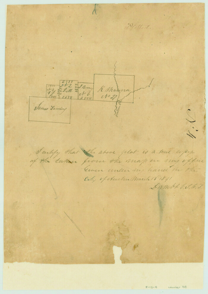
[Surveys near Onion Creek]
Print $2.00
- Digital $50.00
[Surveys near Onion Creek]
1841
Size: 11.0 x 7.8 inches
108
Guadalupe County Sketch File 22

Print $20.00
- Digital $50.00
Guadalupe County Sketch File 22
1957
Size: 16.2 x 16.5 inches
11591
Hays County Sketch File 19a

Print $39.00
- Digital $50.00
Hays County Sketch File 19a
1894
Size: 19.4 x 28.6 inches
11749
Hays County Sketch File 28

Print $20.00
- Digital $50.00
Hays County Sketch File 28
1912
Size: 26.0 x 20.0 inches
11750
Hays County Sketch File 29

Print $20.00
- Digital $50.00
Hays County Sketch File 29
1938
Size: 21.3 x 31.7 inches
11751
Travis County Sketch File 32

Print $20.00
- Digital $50.00
Travis County Sketch File 32
Size: 25.3 x 32.7 inches
12460
Blanco County Sketch File 51

Print $8.00
- Digital $50.00
Blanco County Sketch File 51
1998
Size: 11.1 x 8.5 inches
14697
Map of Hays County, Texas

Print $20.00
- Digital $50.00
Map of Hays County, Texas
1880
Size: 41.8 x 35.8 inches
16848
[Bastrop District]
Print $40.00
- Digital $50.00
[Bastrop District]
1838
Size: 67.3 x 44.2 inches
16941
Comal County Sketch File 9 1/2

Print $6.00
- Digital $50.00
Comal County Sketch File 9 1/2
Size: 12.9 x 8.4 inches
19018
Comal County Sketch File 20

Print $6.00
- Digital $50.00
Comal County Sketch File 20
1857
Size: 12.4 x 8.1 inches
19039
Comal County Sketch File 21

Print $21.00
- Digital $50.00
Comal County Sketch File 21
1950
Size: 9.1 x 11.4 inches
19041
Connected Map of DeWitt's Colony compiled from the surveys of Byrd Lockhart

Print $40.00
- Digital $50.00
Connected Map of DeWitt's Colony compiled from the surveys of Byrd Lockhart
1831
Size: 39.2 x 54.0 inches
1942
Map of San Marcos

Print $20.00
- Digital $50.00
Map of San Marcos
1942
Size: 27.4 x 21.6 inches
2211
Guadalupe County Sketch File 2

Print $4.00
- Digital $50.00
Guadalupe County Sketch File 2
1848
Size: 9.4 x 8.3 inches
24648
Guadalupe County Sketch File 11

Print $4.00
- Digital $50.00
Guadalupe County Sketch File 11
Size: 8.0 x 12.8 inches
24681
Guadalupe County Sketch File 12

Print $8.00
- Digital $50.00
Guadalupe County Sketch File 12
1869
Size: 12.9 x 8.2 inches
24683
Guadalupe County Sketch File 16

Print $22.00
- Digital $50.00
Guadalupe County Sketch File 16
Size: 15.7 x 12.4 inches
24694
Hays County Sketch File A

Print $6.00
- Digital $50.00
Hays County Sketch File A
1881
Size: 10.8 x 8.4 inches
26186
Hays County Sketch File AB

Print $16.00
- Digital $50.00
Hays County Sketch File AB
1891
Size: 6.3 x 8.7 inches
26189
Hays County Sketch File C

Print $40.00
- Digital $50.00
Hays County Sketch File C
Size: 17.9 x 14.6 inches
26197
Hays County Sketch File 1

Print $2.00
- Digital $50.00
Hays County Sketch File 1
1856
Size: 12.6 x 8.3 inches
26199
Hays County Sketch File 2

Print $4.00
- Digital $50.00
Hays County Sketch File 2
1846
Size: 6.3 x 8.1 inches
26200
Hays County Sketch File 3

Print $4.00
- Digital $50.00
Hays County Sketch File 3
1846
Size: 7.1 x 8.2 inches
26202
Hays County Sketch File 4

Print $4.00
- Digital $50.00
Hays County Sketch File 4
Size: 8.5 x 7.0 inches
26204
Hays County Sketch File 5

Print $4.00
- Digital $50.00
Hays County Sketch File 5
1847
Size: 12.7 x 8.3 inches
26206
Hays County Sketch File 7

Print $4.00
- Digital $50.00
Hays County Sketch File 7
1858
Size: 8.4 x 12.9 inches
26208
Travis County Rolled Sketch 47
Print $40.00
- Digital $50.00
Travis County Rolled Sketch 47
1931
-
Size
57.2 x 25.4 inches
-
Map/Doc
10628
-
Creation Date
1931
[Surveys near Onion Creek]
Print $2.00
- Digital $50.00
[Surveys near Onion Creek]
1841
-
Size
11.0 x 7.8 inches
-
Map/Doc
108
-
Creation Date
1841
Guadalupe County Sketch File 22
Print $20.00
- Digital $50.00
Guadalupe County Sketch File 22
1957
-
Size
16.2 x 16.5 inches
-
Map/Doc
11591
-
Creation Date
1957
Hays County Sketch File 19a
Print $39.00
- Digital $50.00
Hays County Sketch File 19a
1894
-
Size
19.4 x 28.6 inches
-
Map/Doc
11749
-
Creation Date
1894
Hays County Sketch File 28
Print $20.00
- Digital $50.00
Hays County Sketch File 28
1912
-
Size
26.0 x 20.0 inches
-
Map/Doc
11750
-
Creation Date
1912
Hays County Sketch File 29
Print $20.00
- Digital $50.00
Hays County Sketch File 29
1938
-
Size
21.3 x 31.7 inches
-
Map/Doc
11751
-
Creation Date
1938
Travis County Sketch File 32
Print $20.00
- Digital $50.00
Travis County Sketch File 32
-
Size
25.3 x 32.7 inches
-
Map/Doc
12460
Blanco County Sketch File 51
Print $8.00
- Digital $50.00
Blanco County Sketch File 51
1998
-
Size
11.1 x 8.5 inches
-
Map/Doc
14697
-
Creation Date
1998
Map of Hays County, Texas
Print $20.00
- Digital $50.00
Map of Hays County, Texas
1880
-
Size
41.8 x 35.8 inches
-
Map/Doc
16848
-
Creation Date
1880
[Bastrop District]
Print $40.00
- Digital $50.00
[Bastrop District]
1838
-
Size
67.3 x 44.2 inches
-
Map/Doc
16941
-
Creation Date
1838
Hays County

Print $20.00
- Digital $50.00
Hays County
1946
-
Size
44.3 x 41.3 inches
-
Map/Doc
1853
-
Creation Date
1946
Comal County Sketch File 9 1/2
Print $6.00
- Digital $50.00
Comal County Sketch File 9 1/2
-
Size
12.9 x 8.4 inches
-
Map/Doc
19018
Comal County Sketch File 20
Print $6.00
- Digital $50.00
Comal County Sketch File 20
1857
-
Size
12.4 x 8.1 inches
-
Map/Doc
19039
-
Creation Date
1857
Comal County Sketch File 21
Print $21.00
- Digital $50.00
Comal County Sketch File 21
1950
-
Size
9.1 x 11.4 inches
-
Map/Doc
19041
-
Creation Date
1950
Connected Map of DeWitt's Colony compiled from the surveys of Byrd Lockhart
Print $40.00
- Digital $50.00
Connected Map of DeWitt's Colony compiled from the surveys of Byrd Lockhart
1831
-
Size
39.2 x 54.0 inches
-
Map/Doc
1942
-
Creation Date
1831
Map of San Marcos
Print $20.00
- Digital $50.00
Map of San Marcos
1942
-
Size
27.4 x 21.6 inches
-
Map/Doc
2211
-
Creation Date
1942
Kyle

Print $20.00
- Digital $50.00
Kyle
1939
-
Size
14.8 x 13.6 inches
-
Map/Doc
2253
-
Creation Date
1939
Guadalupe County Sketch File 2
Print $4.00
- Digital $50.00
Guadalupe County Sketch File 2
1848
-
Size
9.4 x 8.3 inches
-
Map/Doc
24648
-
Creation Date
1848
Guadalupe County Sketch File 11
Print $4.00
- Digital $50.00
Guadalupe County Sketch File 11
-
Size
8.0 x 12.8 inches
-
Map/Doc
24681
Guadalupe County Sketch File 12
Print $8.00
- Digital $50.00
Guadalupe County Sketch File 12
1869
-
Size
12.9 x 8.2 inches
-
Map/Doc
24683
-
Creation Date
1869
Guadalupe County Sketch File 16
Print $22.00
- Digital $50.00
Guadalupe County Sketch File 16
-
Size
15.7 x 12.4 inches
-
Map/Doc
24694
Hays County Sketch File A
Print $6.00
- Digital $50.00
Hays County Sketch File A
1881
-
Size
10.8 x 8.4 inches
-
Map/Doc
26186
-
Creation Date
1881
Hays County Sketch File AB
Print $16.00
- Digital $50.00
Hays County Sketch File AB
1891
-
Size
6.3 x 8.7 inches
-
Map/Doc
26189
-
Creation Date
1891
Hays County Sketch File C
Print $40.00
- Digital $50.00
Hays County Sketch File C
-
Size
17.9 x 14.6 inches
-
Map/Doc
26197
Hays County Sketch File 1
Print $2.00
- Digital $50.00
Hays County Sketch File 1
1856
-
Size
12.6 x 8.3 inches
-
Map/Doc
26199
-
Creation Date
1856
Hays County Sketch File 2
Print $4.00
- Digital $50.00
Hays County Sketch File 2
1846
-
Size
6.3 x 8.1 inches
-
Map/Doc
26200
-
Creation Date
1846
Hays County Sketch File 3
Print $4.00
- Digital $50.00
Hays County Sketch File 3
1846
-
Size
7.1 x 8.2 inches
-
Map/Doc
26202
-
Creation Date
1846
Hays County Sketch File 4
Print $4.00
- Digital $50.00
Hays County Sketch File 4
-
Size
8.5 x 7.0 inches
-
Map/Doc
26204
Hays County Sketch File 5
Print $4.00
- Digital $50.00
Hays County Sketch File 5
1847
-
Size
12.7 x 8.3 inches
-
Map/Doc
26206
-
Creation Date
1847
Hays County Sketch File 7
Print $4.00
- Digital $50.00
Hays County Sketch File 7
1858
-
Size
8.4 x 12.9 inches
-
Map/Doc
26208
-
Creation Date
1858