McCulloch County Sketch File 5A

Print $20.00
- Digital $50.00
McCulloch County Sketch File 5A
Size: 14.8 x 17.4 inches
12056
Menard County Sketch File 4

Print $20.00
- Digital $50.00
Menard County Sketch File 4
Size: 18.3 x 25.5 inches
12072
Menard County Sketch File 8

Print $20.00
- Digital $50.00
Menard County Sketch File 8
Size: 19.7 x 28.5 inches
12073
McCulloch County Boundary File 1

Print $40.00
- Digital $50.00
McCulloch County Boundary File 1
Size: 9.2 x 33.6 inches
56906
McCulloch County Boundary File 2

Print $6.00
- Digital $50.00
McCulloch County Boundary File 2
Size: 12.9 x 8.3 inches
56908
McCulloch County Boundary File 3

Print $16.00
- Digital $50.00
McCulloch County Boundary File 3
Size: 11.1 x 8.6 inches
56911
McCulloch County Boundary File 64

Print $36.00
- Digital $50.00
McCulloch County Boundary File 64
Size: 9.2 x 8.9 inches
56919
Ft. Worth & Rio Grande Ry. west from Whiteland in McCulloch County

Print $20.00
- Digital $50.00
Ft. Worth & Rio Grande Ry. west from Whiteland in McCulloch County
Size: 35.0 x 46.3 inches
66908
McCulloch County Rolled Sketch 5

Print $20.00
- Digital $50.00
McCulloch County Rolled Sketch 5
Size: 25.7 x 20.9 inches
6716
McCulloch County Rolled Sketch 9

Print $20.00
- Digital $50.00
McCulloch County Rolled Sketch 9
Size: 21.0 x 25.9 inches
6719
McCulloch County Rolled Sketch 10

Print $20.00
- Digital $50.00
McCulloch County Rolled Sketch 10
Size: 45.9 x 33.7 inches
6720
San Saba County Rolled Sketch 2

Print $20.00
- Digital $50.00
San Saba County Rolled Sketch 2
Size: 38.9 x 20.7 inches
7743
San Saba County Rolled Sketch 3

Print $20.00
- Digital $50.00
San Saba County Rolled Sketch 3
Size: 31.9 x 43.3 inches
7744
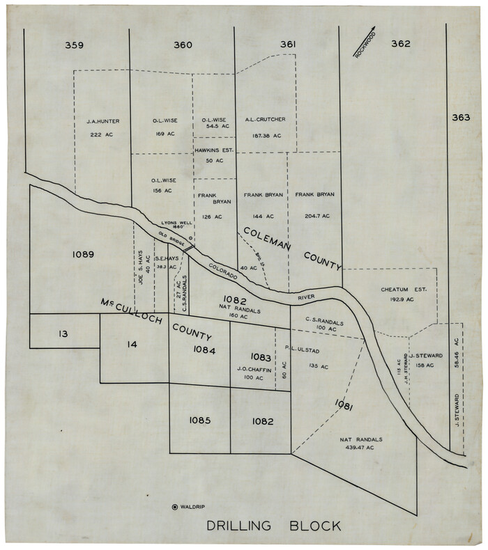
[Coleman and McCullogh County Drilling Block]
Print $20.00
- Digital $50.00
[Coleman and McCullogh County Drilling Block]
Size: 16.6 x 18.6 inches
92968
McCulloch County Rolled Sketch 1

Print $20.00
- Digital $50.00
McCulloch County Rolled Sketch 1
Size: 44.4 x 36.9 inches
9495
McCulloch County Rolled Sketch 2

Digital $50.00
McCulloch County Rolled Sketch 2
Size: 81.6 x 30.0 inches
9496
McCulloch County Rolled Sketch 3

Print $40.00
- Digital $50.00
McCulloch County Rolled Sketch 3
Size: 85.5 x 20.8 inches
9497
McCulloch County Sketch File 1

Print $4.00
- Digital $50.00
McCulloch County Sketch File 1
1854
Size: 8.7 x 6.8 inches
31165
Map of Fisher and Miller's Colony made from the records in the Office of the District Surveyor of Bexar comprising also all the recent surveys

Print $20.00
- Digital $50.00
Map of Fisher and Miller's Colony made from the records in the Office of the District Surveyor of Bexar comprising also all the recent surveys
1855
Size: 23.7 x 35.2 inches
1971
Map of Fisher & Miller's Colony made from the records in the office of the District Surveyor of Bexar comprising also all the recent surveys

Print $20.00
- Digital $50.00
Map of Fisher & Miller's Colony made from the records in the office of the District Surveyor of Bexar comprising also all the recent surveys
1855
Size: 22.6 x 36.2 inches
633
Map of Fisher and Miller's Colony made from the records in the Office of the District Surveyor of Bexar comprising also all the recent surveys

Print $20.00
- Digital $50.00
Map of Fisher and Miller's Colony made from the records in the Office of the District Surveyor of Bexar comprising also all the recent surveys
1855
Size: 27.2 x 39.6 inches
82026
Map of McCulloch County

Print $20.00
- Digital $50.00
Map of McCulloch County
1858
Size: 26.6 x 22.4 inches
3855
McCulloch County Sketch File 2

Print $4.00
- Digital $50.00
McCulloch County Sketch File 2
1872
Size: 12.8 x 8.1 inches
31167
Map of McCulloch County

Print $20.00
- Digital $50.00
Map of McCulloch County
1874
Size: 26.7 x 20.7 inches
3857
McCulloch County, Texas

Print $20.00
- Digital $50.00
McCulloch County, Texas
1879
Size: 24.6 x 18.0 inches
573
McCulloch County Sketch File 4

Print $4.00
- Digital $50.00
McCulloch County Sketch File 4
1883
Size: 11.1 x 8.5 inches
31175
McCulloch County Sketch File 9

Print $6.00
- Digital $50.00
McCulloch County Sketch File 9
1883
Size: 7.3 x 8.7 inches
31184
McCulloch County Sketch File 3

Print $12.00
- Digital $50.00
McCulloch County Sketch File 3
1893
Size: 11.1 x 8.5 inches
31169
McCulloch County Sketch File 5A
Print $20.00
- Digital $50.00
McCulloch County Sketch File 5A
-
Size
14.8 x 17.4 inches
-
Map/Doc
12056
Menard County Sketch File 4
Print $20.00
- Digital $50.00
Menard County Sketch File 4
-
Size
18.3 x 25.5 inches
-
Map/Doc
12072
Menard County Sketch File 8
Print $20.00
- Digital $50.00
Menard County Sketch File 8
-
Size
19.7 x 28.5 inches
-
Map/Doc
12073
McCulloch County Boundary File 1
Print $40.00
- Digital $50.00
McCulloch County Boundary File 1
-
Size
9.2 x 33.6 inches
-
Map/Doc
56906
McCulloch County Boundary File 2
Print $6.00
- Digital $50.00
McCulloch County Boundary File 2
-
Size
12.9 x 8.3 inches
-
Map/Doc
56908
McCulloch County Boundary File 3
Print $16.00
- Digital $50.00
McCulloch County Boundary File 3
-
Size
11.1 x 8.6 inches
-
Map/Doc
56911
McCulloch County Boundary File 64
Print $36.00
- Digital $50.00
McCulloch County Boundary File 64
-
Size
9.2 x 8.9 inches
-
Map/Doc
56919
Ft. Worth & Rio Grande Ry. west from Whiteland in McCulloch County
Print $20.00
- Digital $50.00
Ft. Worth & Rio Grande Ry. west from Whiteland in McCulloch County
-
Size
35.0 x 46.3 inches
-
Map/Doc
66908
McCulloch County Rolled Sketch 5
Print $20.00
- Digital $50.00
McCulloch County Rolled Sketch 5
-
Size
25.7 x 20.9 inches
-
Map/Doc
6716
McCulloch County Rolled Sketch 9
Print $20.00
- Digital $50.00
McCulloch County Rolled Sketch 9
-
Size
21.0 x 25.9 inches
-
Map/Doc
6719
McCulloch County Rolled Sketch 10
Print $20.00
- Digital $50.00
McCulloch County Rolled Sketch 10
-
Size
45.9 x 33.7 inches
-
Map/Doc
6720
San Saba County Rolled Sketch 2
Print $20.00
- Digital $50.00
San Saba County Rolled Sketch 2
-
Size
38.9 x 20.7 inches
-
Map/Doc
7743
San Saba County Rolled Sketch 3
Print $20.00
- Digital $50.00
San Saba County Rolled Sketch 3
-
Size
31.9 x 43.3 inches
-
Map/Doc
7744
[Coleman and McCullogh County Drilling Block]
Print $20.00
- Digital $50.00
[Coleman and McCullogh County Drilling Block]
-
Size
16.6 x 18.6 inches
-
Map/Doc
92968
McCulloch County Rolled Sketch 1
Print $20.00
- Digital $50.00
McCulloch County Rolled Sketch 1
-
Size
44.4 x 36.9 inches
-
Map/Doc
9495
McCulloch County Rolled Sketch 2
Digital $50.00
McCulloch County Rolled Sketch 2
-
Size
81.6 x 30.0 inches
-
Map/Doc
9496
McCulloch County Rolled Sketch 3
Print $40.00
- Digital $50.00
McCulloch County Rolled Sketch 3
-
Size
85.5 x 20.8 inches
-
Map/Doc
9497
McCulloch County Sketch File 1
Print $4.00
- Digital $50.00
McCulloch County Sketch File 1
1854
-
Size
8.7 x 6.8 inches
-
Map/Doc
31165
-
Creation Date
1854
Map of Fisher and Miller's Colony made from the records in the Office of the District Surveyor of Bexar comprising also all the recent surveys
Print $20.00
- Digital $50.00
Map of Fisher and Miller's Colony made from the records in the Office of the District Surveyor of Bexar comprising also all the recent surveys
1855
-
Size
23.7 x 35.2 inches
-
Map/Doc
1971
-
Creation Date
1855
Map of Fisher & Miller's Colony made from the records in the office of the District Surveyor of Bexar comprising also all the recent surveys
Print $20.00
- Digital $50.00
Map of Fisher & Miller's Colony made from the records in the office of the District Surveyor of Bexar comprising also all the recent surveys
1855
-
Size
22.6 x 36.2 inches
-
Map/Doc
633
-
Creation Date
1855
Map of Fisher and Miller's Colony made from the records in the Office of the District Surveyor of Bexar comprising also all the recent surveys
Print $20.00
- Digital $50.00
Map of Fisher and Miller's Colony made from the records in the Office of the District Surveyor of Bexar comprising also all the recent surveys
1855
-
Size
27.2 x 39.6 inches
-
Map/Doc
82026
-
Creation Date
1855
Map of McCulloch County
Print $20.00
- Digital $50.00
Map of McCulloch County
1858
-
Size
26.6 x 22.4 inches
-
Map/Doc
3855
-
Creation Date
1858
McCulloch County Sketch File 2
Print $4.00
- Digital $50.00
McCulloch County Sketch File 2
1872
-
Size
12.8 x 8.1 inches
-
Map/Doc
31167
-
Creation Date
1872
McCulloch County

Print $20.00
- Digital $50.00
McCulloch County
1874
-
Size
21.9 x 16.8 inches
-
Map/Doc
3856
-
Creation Date
1874
Map of McCulloch County
Print $20.00
- Digital $50.00
Map of McCulloch County
1874
-
Size
26.7 x 20.7 inches
-
Map/Doc
3857
-
Creation Date
1874
McCulloch County
Print $20.00
- Digital $50.00
McCulloch County
1877
-
Size
21.3 x 17.9 inches
-
Map/Doc
3858
-
Creation Date
1877
McCulloch County, Texas
Print $20.00
- Digital $50.00
McCulloch County, Texas
1879
-
Size
24.6 x 18.0 inches
-
Map/Doc
573
-
Creation Date
1879
McCulloch County Sketch File 4
Print $4.00
- Digital $50.00
McCulloch County Sketch File 4
1883
-
Size
11.1 x 8.5 inches
-
Map/Doc
31175
-
Creation Date
1883
McCulloch County Sketch File 9
Print $6.00
- Digital $50.00
McCulloch County Sketch File 9
1883
-
Size
7.3 x 8.7 inches
-
Map/Doc
31184
-
Creation Date
1883
McCulloch County Sketch File 3
Print $12.00
- Digital $50.00
McCulloch County Sketch File 3
1893
-
Size
11.1 x 8.5 inches
-
Map/Doc
31169
-
Creation Date
1893