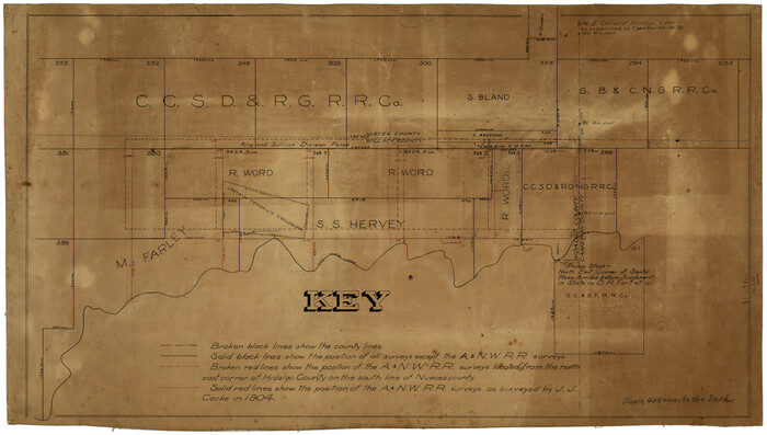
[Surveying Sketch of M. Farley, R. Word, S. S. Hervey, et al in Kleberg County, Texas]
Print $20.00
- Digital $50.00
[Surveying Sketch of M. Farley, R. Word, S. S. Hervey, et al in Kleberg County, Texas]
Size: 23.2 x 40.6 inches
10783
Texas Gulf Coast Map from the Sabine River to the Rio Grande as subdivided for mineral development

Print $40.00
- Digital $50.00
Texas Gulf Coast Map from the Sabine River to the Rio Grande as subdivided for mineral development
Size: 117.9 x 46.0 inches
2902
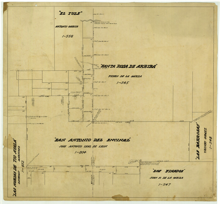
[Map of the San Antonio del Encinal as Corrected]
Print $20.00
- Digital $50.00
[Map of the San Antonio del Encinal as Corrected]
Size: 28.5 x 30.7 inches
4459
Willacy County Boundary File 1

Print $23.00
- Digital $50.00
Willacy County Boundary File 1
Size: 11.3 x 8.8 inches
59956
Willacy County Boundary File 2

Print $16.00
- Digital $50.00
Willacy County Boundary File 2
Size: 11.0 x 8.7 inches
59967
Padre Island National Seashore

Print $4.00
- Digital $50.00
Padre Island National Seashore
Size: 16.1 x 22.3 inches
60538
Padre Island National Seashore

Print $4.00
- Digital $50.00
Padre Island National Seashore
Size: 15.9 x 22.3 inches
60539
Padre Island National Seashore

Print $4.00
- Digital $50.00
Padre Island National Seashore
Size: 16.1 x 22.3 inches
60540
Padre Island National Seashore

Print $4.00
- Digital $50.00
Padre Island National Seashore
Size: 16.1 x 22.4 inches
60541
Sketch for Mineral Application 33721 - 33725 Incl (Attorney General) - Map of Padre Island - Cameron, Willacy, Kleberg, Nueces and Kenedy Counties.

Print $20.00
- Digital $50.00
Sketch for Mineral Application 33721 - 33725 Incl (Attorney General) - Map of Padre Island - Cameron, Willacy, Kleberg, Nueces and Kenedy Counties.
Size: 43.3 x 23.1 inches
65663
[Sketch for Mineral Application 33721 - 33725 Incl. - Padre and Mustang Island]
Print $20.00
- Digital $50.00
[Sketch for Mineral Application 33721 - 33725 Incl. - Padre and Mustang Island]
Size: 42.3 x 22.6 inches
65664

Laguna Madre, T-9211

Print $20.00
- Digital $50.00
Laguna Madre, T-9211
Size: 33.0 x 31.1 inches
73602
Laguna Madre, T-9212

Print $20.00
- Digital $50.00
Laguna Madre, T-9212
Size: 33.1 x 31.4 inches
73603
Map showing surveys involved in Cause No. 28888, State vs. Sullivan et al Travis County, Texas

Print $20.00
- Digital $50.00
Map showing surveys involved in Cause No. 28888, State vs. Sullivan et al Travis County, Texas
Size: 23.0 x 40.7 inches
75989
Willacy County Sketch File 3

Print $2.00
- Digital $50.00
Willacy County Sketch File 3
Size: 8.5 x 11.0 inches
90000
Laguna Madre, Texas from Latitude 26° 20' to 26° 27'

Print $40.00
- Digital $50.00
Laguna Madre, Texas from Latitude 26° 20' to 26° 27'
1879
Size: 32.7 x 55.0 inches
73498
Coast Chart No. 212 - From Latitude 26° 33' to the Rio Grande, Texas

Print $20.00
- Digital $50.00
Coast Chart No. 212 - From Latitude 26° 33' to the Rio Grande, Texas
1886
Size: 37.8 x 34.1 inches
73503
Coast Chart No. 212 - From Latitude 26° 33' to the Rio Grande, Texas

Print $20.00
- Digital $50.00
Coast Chart No. 212 - From Latitude 26° 33' to the Rio Grande, Texas
1886
Size: 30.5 x 24.1 inches
73504
Coast Chart No. 212 - From Latitude 26° 33' to the Rio Grande, Texas

Print $20.00
- Digital $50.00
Coast Chart No. 212 - From Latitude 26° 33' to the Rio Grande, Texas
1886
Size: 21.9 x 17.5 inches
73505
Coast Chart No. 211 - Padre I. and Laguna Madre, Lat. 27° 12' to Lat. 26° 33', Texas

Print $20.00
- Digital $50.00
Coast Chart No. 211 - Padre I. and Laguna Madre, Lat. 27° 12' to Lat. 26° 33', Texas
1890
Size: 40.1 x 33.7 inches
73500
Coast Chart No. 211 - Padre I. and Laguna Madre, Lat. 27° 12' to Lat. 26° 33', Texas

Print $20.00
- Digital $50.00
Coast Chart No. 211 - Padre I. and Laguna Madre, Lat. 27° 12' to Lat. 26° 33', Texas
1890
Size: 41.0 x 33.4 inches
73501
Coast Chart No. 211 - Padre I. and Laguna Madre, Lat. 27° 12' to Lat. 26° 33', Texas

Print $20.00
- Digital $50.00
Coast Chart No. 211 - Padre I. and Laguna Madre, Lat. 27° 12' to Lat. 26° 33', Texas
1890
Size: 30.5 x 24.1 inches
73502
St. Louis, Brownsville & Mexico Railway Location Map from Mile 100 to Mile 120

Print $40.00
- Digital $50.00
St. Louis, Brownsville & Mexico Railway Location Map from Mile 100 to Mile 120
1905
Size: 20.0 x 61.2 inches
64167
St. Louis, Brownsville & Mexico Railway Location Map from Mile 80 to Mile 100

Print $40.00
- Digital $50.00
St. Louis, Brownsville & Mexico Railway Location Map from Mile 80 to Mile 100
1905
Size: 19.4 x 60.9 inches
64165
St. Louis, Brownsville & Mexico Railway Location Map from Mile 80 to Mile 100

Print $40.00
- Digital $50.00
St. Louis, Brownsville & Mexico Railway Location Map from Mile 80 to Mile 100
1905
Size: 19.5 x 64.6 inches
64166
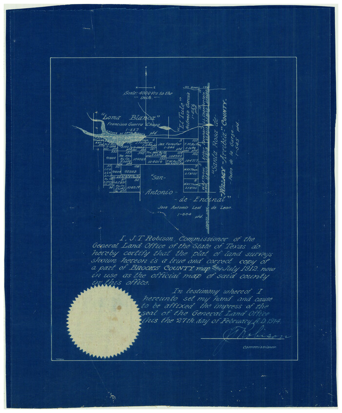
[Sketch Showing Loma Blanca and San Antonio de Encinal Leagues, Brooks County, Texas]
Print $3.00
- Digital $50.00
[Sketch Showing Loma Blanca and San Antonio de Encinal Leagues, Brooks County, Texas]
1912
Size: 15.1 x 11.4 inches
4448
Map showing A. & N. W., Raymond Word #3, S.S. Hervey #496, and M. Farley #495 corrected to conform to the judgement in Cause #2888, Travis County District Court, State of Texas versus D. Sullivan, et al

Print $20.00
- Digital $50.00
Map showing A. & N. W., Raymond Word #3, S.S. Hervey #496, and M. Farley #495 corrected to conform to the judgement in Cause #2888, Travis County District Court, State of Texas versus D. Sullivan, et al
1915
Size: 18.5 x 30.0 inches
75812
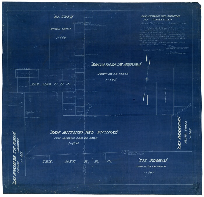
Map of the San Antonio del Encinal as Corrected

Print $20.00
- Digital $50.00
Map of the San Antonio del Encinal as Corrected
1916
Size: 28.5 x 30.6 inches
4456
San Antonio del Encinal as Corrected
Print $20.00
- Digital $50.00
San Antonio del Encinal as Corrected
1916
Size: 31.2 x 31.5 inches
10757
[Surveying Sketch of M. Farley, R. Word, S. S. Hervey, et al in Kleberg County, Texas]
Print $20.00
- Digital $50.00
[Surveying Sketch of M. Farley, R. Word, S. S. Hervey, et al in Kleberg County, Texas]
-
Size
23.2 x 40.6 inches
-
Map/Doc
10783
Texas Gulf Coast Map from the Sabine River to the Rio Grande as subdivided for mineral development
Print $40.00
- Digital $50.00
Texas Gulf Coast Map from the Sabine River to the Rio Grande as subdivided for mineral development
-
Size
117.9 x 46.0 inches
-
Map/Doc
2902
[Map of the San Antonio del Encinal as Corrected]
Print $20.00
- Digital $50.00
[Map of the San Antonio del Encinal as Corrected]
-
Size
28.5 x 30.7 inches
-
Map/Doc
4459
Willacy County Boundary File 1
Print $23.00
- Digital $50.00
Willacy County Boundary File 1
-
Size
11.3 x 8.8 inches
-
Map/Doc
59956
Willacy County Boundary File 2
Print $16.00
- Digital $50.00
Willacy County Boundary File 2
-
Size
11.0 x 8.7 inches
-
Map/Doc
59967
Padre Island National Seashore
Print $4.00
- Digital $50.00
Padre Island National Seashore
-
Size
16.1 x 22.3 inches
-
Map/Doc
60538
Padre Island National Seashore
Print $4.00
- Digital $50.00
Padre Island National Seashore
-
Size
15.9 x 22.3 inches
-
Map/Doc
60539
Padre Island National Seashore
Print $4.00
- Digital $50.00
Padre Island National Seashore
-
Size
16.1 x 22.3 inches
-
Map/Doc
60540
Padre Island National Seashore
Print $4.00
- Digital $50.00
Padre Island National Seashore
-
Size
16.1 x 22.4 inches
-
Map/Doc
60541
Sketch for Mineral Application 33721 - 33725 Incl (Attorney General) - Map of Padre Island - Cameron, Willacy, Kleberg, Nueces and Kenedy Counties.
Print $20.00
- Digital $50.00
Sketch for Mineral Application 33721 - 33725 Incl (Attorney General) - Map of Padre Island - Cameron, Willacy, Kleberg, Nueces and Kenedy Counties.
-
Size
43.3 x 23.1 inches
-
Map/Doc
65663
[Sketch for Mineral Application 33721 - 33725 Incl. - Padre and Mustang Island]
Print $20.00
- Digital $50.00
[Sketch for Mineral Application 33721 - 33725 Incl. - Padre and Mustang Island]
-
Size
42.3 x 22.6 inches
-
Map/Doc
65664
Laguna Madre, T-9211
Print $20.00
- Digital $50.00
Laguna Madre, T-9211
-
Size
33.0 x 31.1 inches
-
Map/Doc
73602
Laguna Madre, T-9212
Print $20.00
- Digital $50.00
Laguna Madre, T-9212
-
Size
33.1 x 31.4 inches
-
Map/Doc
73603
Map showing surveys involved in Cause No. 28888, State vs. Sullivan et al Travis County, Texas
Print $20.00
- Digital $50.00
Map showing surveys involved in Cause No. 28888, State vs. Sullivan et al Travis County, Texas
-
Size
23.0 x 40.7 inches
-
Map/Doc
75989
Willacy County Sketch File 3
Print $2.00
- Digital $50.00
Willacy County Sketch File 3
-
Size
8.5 x 11.0 inches
-
Map/Doc
90000
Laguna Madre, Texas from Latitude 26° 20' to 26° 27'
Print $40.00
- Digital $50.00
Laguna Madre, Texas from Latitude 26° 20' to 26° 27'
1879
-
Size
32.7 x 55.0 inches
-
Map/Doc
73498
-
Creation Date
1879
Coast Chart No. 212 - From Latitude 26° 33' to the Rio Grande, Texas
Print $20.00
- Digital $50.00
Coast Chart No. 212 - From Latitude 26° 33' to the Rio Grande, Texas
1886
-
Size
37.8 x 34.1 inches
-
Map/Doc
73503
-
Creation Date
1886
Coast Chart No. 212 - From Latitude 26° 33' to the Rio Grande, Texas
Print $20.00
- Digital $50.00
Coast Chart No. 212 - From Latitude 26° 33' to the Rio Grande, Texas
1886
-
Size
30.5 x 24.1 inches
-
Map/Doc
73504
-
Creation Date
1886
Coast Chart No. 212 - From Latitude 26° 33' to the Rio Grande, Texas
Print $20.00
- Digital $50.00
Coast Chart No. 212 - From Latitude 26° 33' to the Rio Grande, Texas
1886
-
Size
21.9 x 17.5 inches
-
Map/Doc
73505
-
Creation Date
1886
Coast Chart No. 211 - Padre I. and Laguna Madre, Lat. 27° 12' to Lat. 26° 33', Texas
Print $20.00
- Digital $50.00
Coast Chart No. 211 - Padre I. and Laguna Madre, Lat. 27° 12' to Lat. 26° 33', Texas
1890
-
Size
40.1 x 33.7 inches
-
Map/Doc
73500
-
Creation Date
1890
Coast Chart No. 211 - Padre I. and Laguna Madre, Lat. 27° 12' to Lat. 26° 33', Texas
Print $20.00
- Digital $50.00
Coast Chart No. 211 - Padre I. and Laguna Madre, Lat. 27° 12' to Lat. 26° 33', Texas
1890
-
Size
41.0 x 33.4 inches
-
Map/Doc
73501
-
Creation Date
1890
Coast Chart No. 211 - Padre I. and Laguna Madre, Lat. 27° 12' to Lat. 26° 33', Texas
Print $20.00
- Digital $50.00
Coast Chart No. 211 - Padre I. and Laguna Madre, Lat. 27° 12' to Lat. 26° 33', Texas
1890
-
Size
30.5 x 24.1 inches
-
Map/Doc
73502
-
Creation Date
1890
St. Louis, Brownsville & Mexico Railway Location Map from Mile 100 to Mile 120
Print $40.00
- Digital $50.00
St. Louis, Brownsville & Mexico Railway Location Map from Mile 100 to Mile 120
1905
-
Size
20.0 x 61.2 inches
-
Map/Doc
64167
-
Creation Date
1905
St. Louis, Brownsville & Mexico Railway Location Map from Mile 80 to Mile 100
Print $40.00
- Digital $50.00
St. Louis, Brownsville & Mexico Railway Location Map from Mile 80 to Mile 100
1905
-
Size
19.4 x 60.9 inches
-
Map/Doc
64165
-
Creation Date
1905
St. Louis, Brownsville & Mexico Railway Location Map from Mile 80 to Mile 100
Print $40.00
- Digital $50.00
St. Louis, Brownsville & Mexico Railway Location Map from Mile 80 to Mile 100
1905
-
Size
19.5 x 64.6 inches
-
Map/Doc
64166
-
Creation Date
1905
[Sketch Showing Loma Blanca and San Antonio de Encinal Leagues, Brooks County, Texas]
Print $3.00
- Digital $50.00
[Sketch Showing Loma Blanca and San Antonio de Encinal Leagues, Brooks County, Texas]
1912
-
Size
15.1 x 11.4 inches
-
Map/Doc
4448
-
Creation Date
1912
Map showing A. & N. W., Raymond Word #3, S.S. Hervey #496, and M. Farley #495 corrected to conform to the judgement in Cause #2888, Travis County District Court, State of Texas versus D. Sullivan, et al
Print $20.00
- Digital $50.00
Map showing A. & N. W., Raymond Word #3, S.S. Hervey #496, and M. Farley #495 corrected to conform to the judgement in Cause #2888, Travis County District Court, State of Texas versus D. Sullivan, et al
1915
-
Size
18.5 x 30.0 inches
-
Map/Doc
75812
-
Creation Date
1915
Map of the San Antonio del Encinal as Corrected
Print $20.00
- Digital $50.00
Map of the San Antonio del Encinal as Corrected
1916
-
Size
28.5 x 30.6 inches
-
Map/Doc
4456
-
Creation Date
1916
San Antonio del Encinal as Corrected
Print $20.00
- Digital $50.00
San Antonio del Encinal as Corrected
1916
-
Size
31.2 x 31.5 inches
-
Map/Doc
10757
-
Creation Date
1916