Railroad and County Map of Texas

Print $20.00
- Digital $50.00
Railroad and County Map of Texas
1906
Size: 46.0 x 47.6 inches
10748
Texas Railroad Map

Print $20.00
- Digital $50.00
Texas Railroad Map
1981
Size: 34.8 x 35.6 inches
2101
Rand, McNally and Co.'s New Enlarged Scale Railroad and County Map of Texas, Showing Every Railroad Station and Post Office in the State

Print $20.00
- Digital $50.00
Rand, McNally and Co.'s New Enlarged Scale Railroad and County Map of Texas, Showing Every Railroad Station and Post Office in the State
1882
Size: 23.7 x 29.8 inches
2135
Railroad and County Map of Texas

Print $20.00
- Digital $50.00
Railroad and County Map of Texas
1908
Size: 42.7 x 44.7 inches
2141
Map of the Recognised Line M. EL. P. & P. R. R. from East Line of Bexar Land District to El Paso

Print $20.00
- Digital $50.00
Map of the Recognised Line M. EL. P. & P. R. R. from East Line of Bexar Land District to El Paso
1857
Size: 7.5 x 41.8 inches
2218
Map of the Lands Surveyed by the Memphis, El Paso & Pacific R.R. Company

Print $20.00
- Digital $50.00
Map of the Lands Surveyed by the Memphis, El Paso & Pacific R.R. Company
1859
Size: 15.0 x 30.0 inches
2219
T&P Ry. from Texarkana to Atlanta

Print $40.00
- Digital $50.00
T&P Ry. from Texarkana to Atlanta
1910
Size: 19.8 x 77.4 inches
2327
The Railroad System of Texas on September 1st, 1887

Print $20.00
- Digital $50.00
The Railroad System of Texas on September 1st, 1887
1887
Size: 22.2 x 28.2 inches
3036
Texas & Pacific Ry Reserve west of the Pecos River

Print $40.00
- Digital $50.00
Texas & Pacific Ry Reserve west of the Pecos River
1880
Size: 43.9 x 90.6 inches
3047
Map and Profile No. 1 from the Red River to the Rio Grande; from Explorations and surveys made under the direction of the Hon. Jeffeson Davis, Secretary of War

Print $40.00
- Digital $50.00
Map and Profile No. 1 from the Red River to the Rio Grande; from Explorations and surveys made under the direction of the Hon. Jeffeson Davis, Secretary of War
1856
Size: 30.5 x 57.0 inches
4330
Map of the Lands Surveyed by the Memphis, El Paso & Pacific R.R. Company

Print $20.00
- Digital $50.00
Map of the Lands Surveyed by the Memphis, El Paso & Pacific R.R. Company
1859
Size: 15.8 x 19.0 inches
4844
Map of the Lands Surveyed by the Memphis, El Paso & Pacific R.R. Company

Print $20.00
- Digital $50.00
Map of the Lands Surveyed by the Memphis, El Paso & Pacific R.R. Company
1860
Size: 16.7 x 24.7 inches
4845
Map of the Lands Surveyed by the Memphis, El Paso & Pacific R.R. Company

Print $20.00
- Digital $50.00
Map of the Lands Surveyed by the Memphis, El Paso & Pacific R.R. Company
1860
Size: 18.6 x 19.0 inches
4846
Map of the Lands Surveyed by the Memphis, El Paso & Pacific R.R. Company

Print $20.00
- Digital $50.00
Map of the Lands Surveyed by the Memphis, El Paso & Pacific R.R. Company
1859
Size: 19.7 x 23.3 inches
4847
Map of the Lands Surveyed by the Memphis, El Paso & Pacific R.R. Company

Print $20.00
- Digital $50.00
Map of the Lands Surveyed by the Memphis, El Paso & Pacific R.R. Company
1860
Size: 20.1 x 20.8 inches
4848
Map of the Lands Surveyed by the Memphis, El Paso & Pacific R.R. Company

Print $20.00
- Digital $50.00
Map of the Lands Surveyed by the Memphis, El Paso & Pacific R.R. Company
1859
Size: 13.9 x 21.3 inches
4849
Map of the Lands Surveyed by the Memphis, El Paso & Pacific R.R. Company

Print $20.00
- Digital $50.00
Map of the Lands Surveyed by the Memphis, El Paso & Pacific R.R. Company
1859
Size: 11.4 x 18.6 inches
4850
Map of the Lands Surveyed by the Memphis, El Paso & Pacific R.R. Company

Print $20.00
- Digital $50.00
Map of the Lands Surveyed by the Memphis, El Paso & Pacific R.R. Company
1860
Size: 17.7 x 21.7 inches
4851
[List of W.C. RR. Co. Certificates]
![60504, [List of W.C. RR. Co. Certificates], General Map Collection](https://historictexasmaps.com/wmedia_w700/pdf_converted_jpg/qi_pdf_thumbnail_17018.jpg)
Print $28.00
[List of W.C. RR. Co. Certificates]
1930
Size: 14.4 x 8.9 inches
60504
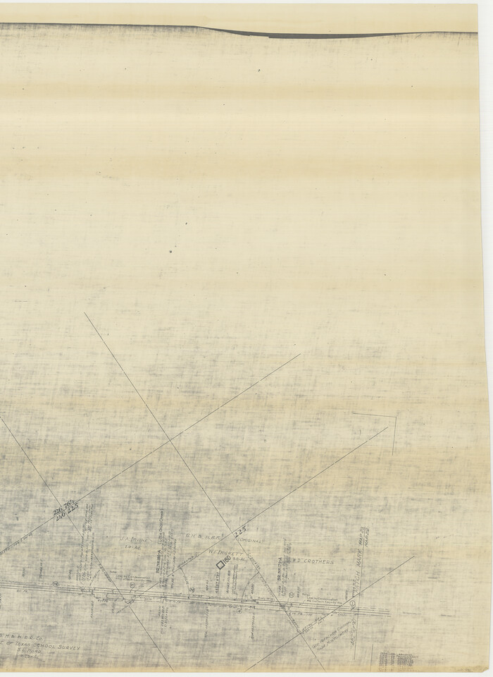
FT. W. & R. G. Ry. Right of Way Map, Winchell to Brady, McCulloch County, Texas

Print $40.00
- Digital $50.00
FT. W. & R. G. Ry. Right of Way Map, Winchell to Brady, McCulloch County, Texas
1918
Size: 38.0 x 121.9 inches
61410
[FT. W. & R. G. Ry. Right of Way Map, Winchell to Brady, McCulloch County, Texas]
Print $20.00
- Digital $50.00
[FT. W. & R. G. Ry. Right of Way Map, Winchell to Brady, McCulloch County, Texas]
1918
Size: 37.0 x 26.9 inches
61411
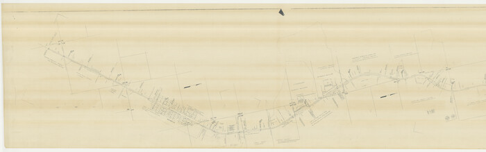
FT. W. & R. G. Ry. Right of Way Map, Whiteland to Lightner, Concho County, Texas

Print $40.00
- Digital $50.00
FT. W. & R. G. Ry. Right of Way Map, Whiteland to Lightner, Concho County, Texas
1918
Size: 39.6 x 121.3 inches
61412
FT. W. & R. G. Ry. Right of Way Map, Whiteland to Lightner, Concho County, Texas

Print $40.00
- Digital $50.00
FT. W. & R. G. Ry. Right of Way Map, Whiteland to Lightner, Concho County, Texas
1918
Size: 37.5 x 68.4 inches
61413
[FT. W. & R. G. Ry. Right of Way Map, Winchell to Brady, McCulloch County, Texas]
Print $40.00
- Digital $50.00
[FT. W. & R. G. Ry. Right of Way Map, Winchell to Brady, McCulloch County, Texas]
1918
Size: 38.2 x 122.0 inches
61414
[FT. W. & R. G. Ry. Right of Way Map, Winchell to Brady, McCulloch County, Texas]
Print $40.00
- Digital $50.00
[FT. W. & R. G. Ry. Right of Way Map, Winchell to Brady, McCulloch County, Texas]
1918
Size: 38.2 x 122.0 inches
61415
FT. W. & R. G. Ry. Right of Way Map, Winchell to Brady, McCulloch County, Texas

Print $20.00
- Digital $50.00
FT. W. & R. G. Ry. Right of Way Map, Winchell to Brady, McCulloch County, Texas
1918
Size: 36.9 x 32.0 inches
61416
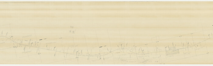
G. C. & S. F. Ry., San Saba Branch Right of Way Map, Melvin to Eden

Print $40.00
- Digital $50.00
G. C. & S. F. Ry., San Saba Branch Right of Way Map, Melvin to Eden
1916
Size: 37.6 x 63.1 inches
61417
G. C. & S. F. Ry., San Saba Branch, Texas, Right of Way Map, Hall to Brady

Print $40.00
- Digital $50.00
G. C. & S. F. Ry., San Saba Branch, Texas, Right of Way Map, Hall to Brady
1916
Size: 38.9 x 124.3 inches
61418
G. C. & S. F. Ry., San Saba Branch, Texas, Right of Way Map, Hall to Brady

Print $20.00
- Digital $50.00
G. C. & S. F. Ry., San Saba Branch, Texas, Right of Way Map, Hall to Brady
1916
Size: 36.9 x 34.0 inches
61419
G. C. & S. F. Ry., San Saba Branch, Right of Way Map, Brady to Melvin

Print $40.00
- Digital $50.00
G. C. & S. F. Ry., San Saba Branch, Right of Way Map, Brady to Melvin
1916
Size: 38.2 x 122.0 inches
61420
Railroad and County Map of Texas
Print $20.00
- Digital $50.00
Railroad and County Map of Texas
1906
-
Size
46.0 x 47.6 inches
-
Map/Doc
10748
-
Creation Date
1906
Texas Railroad Map
Print $20.00
- Digital $50.00
Texas Railroad Map
1981
-
Size
34.8 x 35.6 inches
-
Map/Doc
2101
-
Creation Date
1981
Rand, McNally and Co.'s New Enlarged Scale Railroad and County Map of Texas, Showing Every Railroad Station and Post Office in the State
Print $20.00
- Digital $50.00
Rand, McNally and Co.'s New Enlarged Scale Railroad and County Map of Texas, Showing Every Railroad Station and Post Office in the State
1882
-
Size
23.7 x 29.8 inches
-
Map/Doc
2135
-
Creation Date
1882
Railroad and County Map of Texas
Print $20.00
- Digital $50.00
Railroad and County Map of Texas
1908
-
Size
42.7 x 44.7 inches
-
Map/Doc
2141
-
Creation Date
1908
Map of the Recognised Line M. EL. P. & P. R. R. from East Line of Bexar Land District to El Paso
Print $20.00
- Digital $50.00
Map of the Recognised Line M. EL. P. & P. R. R. from East Line of Bexar Land District to El Paso
1857
-
Size
7.5 x 41.8 inches
-
Map/Doc
2218
-
Creation Date
1857
Map of the Lands Surveyed by the Memphis, El Paso & Pacific R.R. Company
Print $20.00
- Digital $50.00
Map of the Lands Surveyed by the Memphis, El Paso & Pacific R.R. Company
1859
-
Size
15.0 x 30.0 inches
-
Map/Doc
2219
-
Creation Date
1859
T&P Ry. from Texarkana to Atlanta
Print $40.00
- Digital $50.00
T&P Ry. from Texarkana to Atlanta
1910
-
Size
19.8 x 77.4 inches
-
Map/Doc
2327
-
Creation Date
1910
The Railroad System of Texas on September 1st, 1887
Print $20.00
- Digital $50.00
The Railroad System of Texas on September 1st, 1887
1887
-
Size
22.2 x 28.2 inches
-
Map/Doc
3036
-
Creation Date
1887
Texas & Pacific Ry Reserve west of the Pecos River
Print $40.00
- Digital $50.00
Texas & Pacific Ry Reserve west of the Pecos River
1880
-
Size
43.9 x 90.6 inches
-
Map/Doc
3047
-
Creation Date
1880
Map and Profile No. 1 from the Red River to the Rio Grande; from Explorations and surveys made under the direction of the Hon. Jeffeson Davis, Secretary of War
Print $40.00
- Digital $50.00
Map and Profile No. 1 from the Red River to the Rio Grande; from Explorations and surveys made under the direction of the Hon. Jeffeson Davis, Secretary of War
1856
-
Size
30.5 x 57.0 inches
-
Map/Doc
4330
-
Creation Date
1856
Map of the Lands Surveyed by the Memphis, El Paso & Pacific R.R. Company
Print $20.00
- Digital $50.00
Map of the Lands Surveyed by the Memphis, El Paso & Pacific R.R. Company
1859
-
Size
15.8 x 19.0 inches
-
Map/Doc
4844
-
Creation Date
1859
Map of the Lands Surveyed by the Memphis, El Paso & Pacific R.R. Company
Print $20.00
- Digital $50.00
Map of the Lands Surveyed by the Memphis, El Paso & Pacific R.R. Company
1860
-
Size
16.7 x 24.7 inches
-
Map/Doc
4845
-
Creation Date
1860
Map of the Lands Surveyed by the Memphis, El Paso & Pacific R.R. Company
Print $20.00
- Digital $50.00
Map of the Lands Surveyed by the Memphis, El Paso & Pacific R.R. Company
1860
-
Size
18.6 x 19.0 inches
-
Map/Doc
4846
-
Creation Date
1860
Map of the Lands Surveyed by the Memphis, El Paso & Pacific R.R. Company
Print $20.00
- Digital $50.00
Map of the Lands Surveyed by the Memphis, El Paso & Pacific R.R. Company
1859
-
Size
19.7 x 23.3 inches
-
Map/Doc
4847
-
Creation Date
1859
Map of the Lands Surveyed by the Memphis, El Paso & Pacific R.R. Company
Print $20.00
- Digital $50.00
Map of the Lands Surveyed by the Memphis, El Paso & Pacific R.R. Company
1860
-
Size
20.1 x 20.8 inches
-
Map/Doc
4848
-
Creation Date
1860
Map of the Lands Surveyed by the Memphis, El Paso & Pacific R.R. Company
Print $20.00
- Digital $50.00
Map of the Lands Surveyed by the Memphis, El Paso & Pacific R.R. Company
1859
-
Size
13.9 x 21.3 inches
-
Map/Doc
4849
-
Creation Date
1859
Map of the Lands Surveyed by the Memphis, El Paso & Pacific R.R. Company
Print $20.00
- Digital $50.00
Map of the Lands Surveyed by the Memphis, El Paso & Pacific R.R. Company
1859
-
Size
11.4 x 18.6 inches
-
Map/Doc
4850
-
Creation Date
1859
Map of the Lands Surveyed by the Memphis, El Paso & Pacific R.R. Company
Print $20.00
- Digital $50.00
Map of the Lands Surveyed by the Memphis, El Paso & Pacific R.R. Company
1860
-
Size
17.7 x 21.7 inches
-
Map/Doc
4851
-
Creation Date
1860
[List of W.C. RR. Co. Certificates]
Print $28.00
[List of W.C. RR. Co. Certificates]
1930
-
Size
14.4 x 8.9 inches
-
Map/Doc
60504
-
Creation Date
1930
FT. W. & R. G. Ry. Right of Way Map, Winchell to Brady, McCulloch County, Texas
Print $40.00
- Digital $50.00
FT. W. & R. G. Ry. Right of Way Map, Winchell to Brady, McCulloch County, Texas
1918
-
Size
38.0 x 121.9 inches
-
Map/Doc
61410
-
Creation Date
1918
[FT. W. & R. G. Ry. Right of Way Map, Winchell to Brady, McCulloch County, Texas]
Print $20.00
- Digital $50.00
[FT. W. & R. G. Ry. Right of Way Map, Winchell to Brady, McCulloch County, Texas]
1918
-
Size
37.0 x 26.9 inches
-
Map/Doc
61411
-
Creation Date
1918
FT. W. & R. G. Ry. Right of Way Map, Whiteland to Lightner, Concho County, Texas
Print $40.00
- Digital $50.00
FT. W. & R. G. Ry. Right of Way Map, Whiteland to Lightner, Concho County, Texas
1918
-
Size
39.6 x 121.3 inches
-
Map/Doc
61412
-
Creation Date
1918
FT. W. & R. G. Ry. Right of Way Map, Whiteland to Lightner, Concho County, Texas
Print $40.00
- Digital $50.00
FT. W. & R. G. Ry. Right of Way Map, Whiteland to Lightner, Concho County, Texas
1918
-
Size
37.5 x 68.4 inches
-
Map/Doc
61413
-
Creation Date
1918
[FT. W. & R. G. Ry. Right of Way Map, Winchell to Brady, McCulloch County, Texas]
Print $40.00
- Digital $50.00
[FT. W. & R. G. Ry. Right of Way Map, Winchell to Brady, McCulloch County, Texas]
1918
-
Size
38.2 x 122.0 inches
-
Map/Doc
61414
-
Creation Date
1918
[FT. W. & R. G. Ry. Right of Way Map, Winchell to Brady, McCulloch County, Texas]
Print $40.00
- Digital $50.00
[FT. W. & R. G. Ry. Right of Way Map, Winchell to Brady, McCulloch County, Texas]
1918
-
Size
38.2 x 122.0 inches
-
Map/Doc
61415
-
Creation Date
1918
FT. W. & R. G. Ry. Right of Way Map, Winchell to Brady, McCulloch County, Texas
Print $20.00
- Digital $50.00
FT. W. & R. G. Ry. Right of Way Map, Winchell to Brady, McCulloch County, Texas
1918
-
Size
36.9 x 32.0 inches
-
Map/Doc
61416
-
Creation Date
1918
G. C. & S. F. Ry., San Saba Branch Right of Way Map, Melvin to Eden
Print $40.00
- Digital $50.00
G. C. & S. F. Ry., San Saba Branch Right of Way Map, Melvin to Eden
1916
-
Size
37.6 x 63.1 inches
-
Map/Doc
61417
-
Creation Date
1916
G. C. & S. F. Ry., San Saba Branch, Texas, Right of Way Map, Hall to Brady
Print $40.00
- Digital $50.00
G. C. & S. F. Ry., San Saba Branch, Texas, Right of Way Map, Hall to Brady
1916
-
Size
38.9 x 124.3 inches
-
Map/Doc
61418
-
Creation Date
1916
G. C. & S. F. Ry., San Saba Branch, Texas, Right of Way Map, Hall to Brady
Print $20.00
- Digital $50.00
G. C. & S. F. Ry., San Saba Branch, Texas, Right of Way Map, Hall to Brady
1916
-
Size
36.9 x 34.0 inches
-
Map/Doc
61419
-
Creation Date
1916
G. C. & S. F. Ry., San Saba Branch, Right of Way Map, Brady to Melvin
Print $40.00
- Digital $50.00
G. C. & S. F. Ry., San Saba Branch, Right of Way Map, Brady to Melvin
1916
-
Size
38.2 x 122.0 inches
-
Map/Doc
61420
-
Creation Date
1916