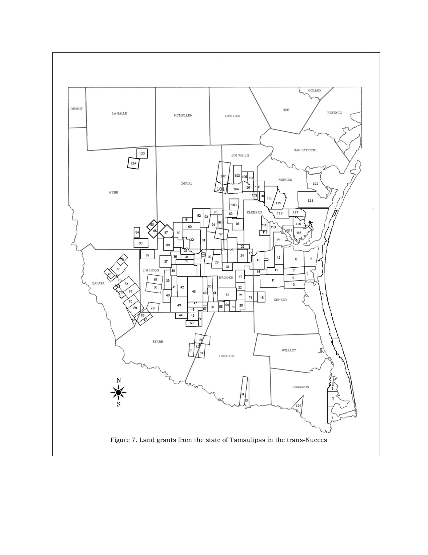
Land grants from the state of Tamaulipas in the trans-Nueces
-
Map/Doc
94040
-
Collection
General Map Collection
-
Object Dates
2009 (Creation Date)
-
People and Organizations
Texas General Land Office (Publisher)
Galen D. Greaser (Author)
Kevin Klaus (Author)
Jeff Perkins (Author)
-
Counties
Webb Cameron Willacy Hidalgo Starr Kenedy Nueces Kleberg Brooks Jim Hogg Zapata Dimmit Duval Jim Wells San Patricio Refugio Goliad Bee Live Oak McMullen La Salle
-
Subjects
Mexican Texas Spanish Texas
-
Height x Width
11.0 x 8.5 inches
27.9 x 21.6 cm
-
Medium
digital image
-
Comments
These grants were made between 1821-1836 by the state of Tamaulipas.
Figure 7 from the "New Guide to Spanish and Mexican Land Grants in South Texas", GLO Doc# 83388 (pp. 102-103).
See 94041-94046 for other figures from this guide.
Related maps
New Guide to Spanish and Mexican Land Grants in South Texas

Price $15.00
New Guide to Spanish and Mexican Land Grants in South Texas
2009
Size 11.0 x 8.5 inches
Map/Doc 83388
Layout of the porciones as described in the Visita General of Camargo, 1767

Layout of the porciones as described in the Visita General of Camargo, 1767
2009
Size 11.0 x 8.5 inches
Map/Doc 94041
Layout of the porciones as described in the Visita General of Laredo, 1767

Layout of the porciones as described in the Visita General of Laredo, 1767
2009
Size 11.0 x 8.5 inches
Map/Doc 94042
Layout of the porciones as described in the Visita General of Mier, 1767

Layout of the porciones as described in the Visita General of Mier, 1767
2009
Size 11.0 x 8.5 inches
Map/Doc 94043
Layout of the porciones as described in the Visita General of Revilla (Guerrero), 1767, along with six tracts distributed by Gov. Lasaga in 1784 and three others (39-41) assigned at a later date

Layout of the porciones as described in the Visita General of Revilla (Guerrero), 1767, along with six tracts distributed by Gov. Lasaga in 1784 and three others (39-41) assigned at a later date
2009
Size 11.0 x 8.5 inches
Map/Doc 94044
Layout of the porciones as described in the Visita General of Reynosa, 1767

Layout of the porciones as described in the Visita General of Reynosa, 1767
2009
Size 11.0 x 8.5 inches
Map/Doc 94045
Spanish land grants (other than porciones) in the trans-Nueces

Spanish land grants (other than porciones) in the trans-Nueces
2009
Size 11.0 x 8.5 inches
Map/Doc 94046
Part of: General Map Collection
Map of Menard County

Print $20.00
- Digital $50.00
Map of Menard County
1894
Size 32.1 x 41.8 inches
Map/Doc 1320
Bell County Sketch File 20a

Print $4.00
- Digital $50.00
Bell County Sketch File 20a
1855
Size 6.7 x 8.3 inches
Map/Doc 14408
Jones & Murphy's Map of the City of Dallas, Texas compiled from the records of Dallas Co., and latest surveys of the City Engineer

Print $20.00
- Digital $50.00
Jones & Murphy's Map of the City of Dallas, Texas compiled from the records of Dallas Co., and latest surveys of the City Engineer
1878
Size 22.0 x 29.9 inches
Map/Doc 97262
[Sketch for Mineral Application 26501 - Sabine River, T. A. Oldhausen]
![2836, [Sketch for Mineral Application 26501 - Sabine River, T. A. Oldhausen], General Map Collection](https://historictexasmaps.com/wmedia_w700/maps/2836.tif.jpg)
Print $20.00
- Digital $50.00
[Sketch for Mineral Application 26501 - Sabine River, T. A. Oldhausen]
1931
Size 24.4 x 36.5 inches
Map/Doc 2836
Archer County Rolled Sketch 9

Print $20.00
- Digital $50.00
Archer County Rolled Sketch 9
1891
Size 35.9 x 30.6 inches
Map/Doc 5104
Calhoun County Rolled Sketch 24

Print $40.00
- Digital $50.00
Calhoun County Rolled Sketch 24
1962
Size 26.0 x 58.3 inches
Map/Doc 5373
Hutchinson County Sketch File 50

Print $12.00
- Digital $50.00
Hutchinson County Sketch File 50
1992
Size 14.2 x 8.8 inches
Map/Doc 27434
Flight Mission No. BRA-6M, Frame 94, Jefferson County

Print $20.00
- Digital $50.00
Flight Mission No. BRA-6M, Frame 94, Jefferson County
1953
Size 18.6 x 22.4 inches
Map/Doc 85437
Gonzales County Working Sketch 12

Print $20.00
- Digital $50.00
Gonzales County Working Sketch 12
1981
Size 13.1 x 11.9 inches
Map/Doc 63228
Old Miscellaneous File 36

Print $4.00
- Digital $50.00
Old Miscellaneous File 36
1891
Size 11.3 x 8.8 inches
Map/Doc 75759
Hansford County

Print $20.00
- Digital $50.00
Hansford County
1889
Size 22.7 x 18.9 inches
Map/Doc 4558
Irion County Sketch File 6

Print $20.00
- Digital $50.00
Irion County Sketch File 6
1900
Size 19.1 x 27.8 inches
Map/Doc 11824
You may also like
[Surveys in the Jefferson District along Big Sandy Creek]
![100, [Surveys in the Jefferson District along Big Sandy Creek], General Map Collection](https://historictexasmaps.com/wmedia_w700/maps/100.tif.jpg)
Print $2.00
- Digital $50.00
[Surveys in the Jefferson District along Big Sandy Creek]
1841
Size 9.5 x 8.1 inches
Map/Doc 100
Jefferson County Rolled Sketch 21

Print $20.00
- Digital $50.00
Jefferson County Rolled Sketch 21
Size 12.6 x 12.1 inches
Map/Doc 6386
Kent County Working Sketch 21

Print $20.00
- Digital $50.00
Kent County Working Sketch 21
1981
Size 43.5 x 37.5 inches
Map/Doc 70028
Donley County Sketch File 6

Print $16.00
- Digital $50.00
Donley County Sketch File 6
1881
Size 12.9 x 8.5 inches
Map/Doc 21230
Castro County

Print $20.00
- Digital $50.00
Castro County
1891
Size 25.4 x 23.1 inches
Map/Doc 66750
Flight Mission No. DAG-17K, Frame 137, Matagorda County

Print $20.00
- Digital $50.00
Flight Mission No. DAG-17K, Frame 137, Matagorda County
1952
Size 16.5 x 16.2 inches
Map/Doc 86354
Midland County Sketch File 13

Print $4.00
- Digital $50.00
Midland County Sketch File 13
1940
Size 11.2 x 8.7 inches
Map/Doc 31576
Culberson County Rolled Sketch 54

Print $40.00
- Digital $50.00
Culberson County Rolled Sketch 54
1968
Size 59.0 x 29.4 inches
Map/Doc 10300
Flight Mission No. DAG-18K, Frame 185, Matagorda County

Print $20.00
- Digital $50.00
Flight Mission No. DAG-18K, Frame 185, Matagorda County
1952
Size 16.2 x 15.9 inches
Map/Doc 86377
Brooks County Sketch File 1

Print $12.00
- Digital $50.00
Brooks County Sketch File 1
1923
Size 14.3 x 8.9 inches
Map/Doc 16537
Edwards County Working Sketch 102

Print $20.00
- Digital $50.00
Edwards County Working Sketch 102
1971
Size 35.0 x 25.5 inches
Map/Doc 68978
[SE Pt. of Stephens County]
![89639, [SE Pt. of Stephens County], Twichell Survey Records](https://historictexasmaps.com/wmedia_w700/maps/89639-1.tif.jpg)
Print $20.00
- Digital $50.00
[SE Pt. of Stephens County]
Size 38.1 x 35.9 inches
Map/Doc 89639